A 4.000-year-old stone slab, first discovered more than a century ago in France, may be the oldest known map in Europe, according to a new study.
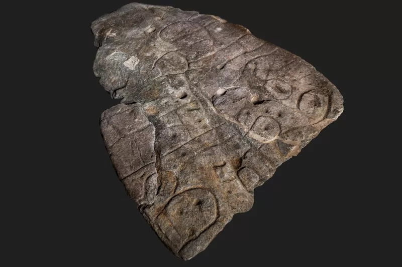
The plate of Saint-Bélec it dates back to the early Bronze Age (2150-1600 BC) and was first discovered in 1900 in a prehistoric cemetery in Finistère, Brittany. It formed one of the walls of a cista, a stone box that housed the bodies of the deceased. The slab was probably made before being reused in the burial towards the end of the Early Bronze Age (1900-1640 BC), according to a statement .
Upon discovery the broken slab, which is 12,7 feet (3,9 meters) long, was moved to a private museum, and the French Museum of National Antiquities purchased it in 1924. It was then stored in a chateau French, where it collected dust until it was rediscovered in the castle cellar in 2014. Only recently are researchers starting to understand the interesting story behind this prehistoric slab.
The oldest “3D” map of Europe
In 2017, a group of researchers in Europe began analyzing the engravings on the plate. He did this using high-resolution 3D surveys and photogrammetry, a process of analyzing an object by taking detailed photographs. They found that the plate had all the marks one would expect from one map, like motifs joined by lines. They also found that the lines represented a river network and that its creators appeared to have deliberately used a 3D shape to represent a valley.
The researchers compared the engravings on the plate with elements of the French landscape. They concluded that the slab represented an area approximately 18,6 miles by 13 miles (30 kilometers by 21 km) along the Odet River in western France.
The slab was a tool for Princes or Kings
“This is probably the oldest map of a territory that has been identified in Europe.” And how much he tells the BBC the author of the study Clement Nicolas from Bournemouth University. The map was probably used by a Bronze Age prince or king to mark ownership over a particular area. It suggests that we should not underestimate the cartographic knowledge of past societies.
The territory was likely owned by a highly hierarchical political entity that tightly controlled the area in the Early Bronze Age, according to the statement.
The fact that the slab was subsequently buried could mean the end of the power of those who had used it.
These and other hypotheses are contained in the results of the study published in the French journal Bulletin de la Société prehistorique française .