Maps from ancient times give us a little glimpse of what landscapes looked like hundreds of years ago. But what would we see if we could send a satellite back in time and observe these places from above?
Henrique Andrade is a student of the Escola Politécnica da Universidade de Pernambuco, Recife, who for several years has been examining ancient maps of his hometown, Recife, in Brazil.
See the past from a new perspective
“I collected all these digital copies of maps and discovered things about my hometown that weren't as widely known,” he says. “I feel that in Recife people have been denied access to their past, which makes it difficult for them to understand who they are and therefore what they can do for their future.”
Andrade turned to a professor from his university, Bruno Fernandes, with an idea: to develop a machine learning algorithm capable of transforming ancient maps into Google satellite images with AI.
Such an approach, he says, could inform people about how land use has changed over time, including the social and economic impacts of urbanization.
Ancient images transformed into satellite maps: the project
To see the project realized, they used an already existing AI tool called Pix2pix, which depends on 2 neural networks. The first creates images based on the input set, while the second chooses whether the generated image is fake or not. Yes, practically it's a GAN. And like all GANs, it "challenges" itself by trying to deceive itself (and to discover the deception). The result? realistic-looking images based on ancient maps and historical data.
Andrade and Fernandes described their approach in a studio published in IEEE Geoscience and Remote Sensing Letters.
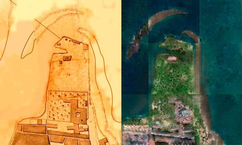
From ancient maps from 212 years ago to a modern satellite image

To illustrate the system, the two scholars "sent a satellite back in time" providing the AI with ancient maps of Recife dating back to 1808. The system therefore generated modern images of the area.
When you look at the images, you get a better understanding of how the city has changed in 200 years. The geography of the city has changed dramatically: landfills have reduced water bodies and green areas have all been removed by human activity.
Henrique Andrade, Escola Politécnica from Universidade de Pernambuco
Pros: This AI requires relatively little input volume to generate a satellite map. Cons: Just an image isn't enough, you need to provide historical context.
And on all the resolution of the images generated must be further improved.
Next steps: ancient maps in 4k images?
“We are working on improving the resolution of the images and experimenting with different inputs,” says Andrade.
Let's hope. This approach to generating modern images of the past is widely applicable.