As a good Neapolitan, I'm a bit of a meteorologist: when there are clouds around, I feel a bit depressed. Yet, news like this makes me understand that a cloudy day can also generate a lot of enthusiasm. At least since the new European meteorological satellite has been in the sky, Meteosat Third Generation – Imager 1 (MTG-I1). From today we have a completely new look at the Earth, like never before.
Launched last December, Meteosat MTG-I1 is the result of collaboration between the European Organization for the Operation of Meteorological Satellites (EUMETSAT) and the European Space Agency (ESA). And he's sending the first, startling images of our planet in unprecedented detail.
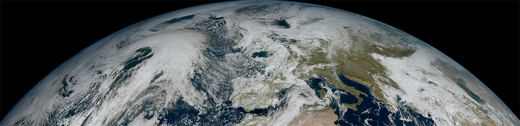
From the clouds to the Alps: never seen like this
The first images captured by the new Meteosat Europa show a meteorological situation over Europe, Africa and the Atlantic with a level of detail that leaves you speechless. The high resolution of the satellite allows many details to be clearly observed. For example, the vortex-shaped cloud structures over the Canary Islands. Or the snow cover in the Alps. Even the sediments along the Italian coasts.
This level of detail will revolutionize the way we monitor and predict the weather, helping meteorologists to quickly and more accurately pinpoint extreme weather phenomena. All thanks to European teamwork, which for once has shown no divisions. With a protagonist with an (also) Italian heart: Thales Alenia Space.
Love at first sight

Simonetta Cheli, director of the Earth Observation programs of theESA, expressed great pride in the first image of MTG-I1 released just today. The director underlined that this cloudy but highly detailed image is an example of what can be achieved through European cooperation in space. There's something to be proud of, in short.
The fundamental ingredient of Meteosat
The Italian-French joint venture Thales Alenia Space developed the instrument Flexible Combined Imager: is at the heart of the production of these spectacular images. In this first phase of commissioning (it will last until December 2023) the satellite instruments will be tested and calibrated. At the end of the year, its data will be distributed to meteorological services for operational use in weather forecasting.

Thanks to the technological advances of MTG-I1, meteosat images will be produced more frequently and with a much higher resolution than second-generation Meteosat satellites. This will allow meteorologists to monitor the weather in real time and with unprecedented precision. When the system becomes operational, images of the entire Earth disk will be produced 10 every minute. A definite significant step forward compared to current monitoring capabilities.
With the new Meteosat we will be more aware, and (I hope) more reactive
I have no doubt that Meteosat Europa will have a significant impact: it will help us prevent and mitigate the risks associated with extreme weather phenomena, such as floods, storms and droughts. It will make our planet better prepared to meet the challenges of the ever-changing climate. And it will provide a more accurate view of weather phenomena and their evolution, enabling meteorologists to make more informed decisions and provide more accurate forecasts.
I don't know if it will make me less meteoropathic, but it will certainly be useful to the rest of the world.